
Google has formally launched its 3D mapping and imagery technology, launching a service called Google Earth, a name that seems to fit the search company's global ambitions.
Google Earth uses satellite-based maps based on the Keyhole technology Google acquired earlier this year to create three-dimensional, interactive maps that users can manipulate to find specific locations and other information.
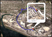
With the tool, users can zoom from bird's eye view of a city to a street-level view, where buildings in major U.S. cities are show in proportional sizes. Three-dimensional imagery also can show mountains, valleys and canyons.
Significant Development
Google Earth is being integrated into Google's local search tool and is being touted as a way of making it easier for users to find exactly what they're looking for. For instance, one feature allows for driving directions to be acted out in a 3D video playback environment.
"Google Earth utilizes broadband streaming technology and 3D graphics, much like a videogame, enabling users to interactively explore the world -- either their own neighborhood or the far corners of the globe," said John Hanke, general manager for the Keyhole unit at Google. "With many ways to access geographic information, Google provides a very rich local search experience for users worldwide."
The map technology hits the market just days after MSN beefed up its own local search with more interactive features. As part of that launch, MSN hinted that more map products would be coming as it moved its satellite mapping group into the local search unit to launch a product called MSN Virtual Earth.
Analysts say the blending of map technology and search might be one of the most significant new developments in the search arena, with the power to change how people search for many types of information both from PCs and from mobile devices.
Powerful Stew
Google said the Earth feature would be useful for several groups of Web users, including those searching for new homes, who can use the tool to see images of a neighborhood and then save their searches for future reference.
The basic Google Earth is being offered for free as a download from Google. Also available are advanced services, including Google Earth Plus, for US$20 per year, which includes compatibility with GPS devices, and Google Earth Pro, which costs $400 annually and offers high-resolution images and printing capabilities for commercial users such as real estate agents.
Search Engine Journal Editor Loren Baker called the blending of local search and mapping a "powerful mix," one that MSN is also working toward.
"But, as always, Google beat the others to the announcement by rebranding and adding some Google-esque touches to its Keyhole offering," Baker wrote.
Maps Aplenty
The release came a day after Google's shares shot above the $300 barrier for the first time since the company went public last summer. Google shares, which debuted in August of 2004 at $85 each after weeks of hype, have soared in recent weeks, amid some analyst predictions that the stock will reach $350 or more based on its earnings and revenue growth projections.
The stock surged yesterday on Google's move toward a system that will one day enable pay-per-view video downloads and streaming, an offering now seen as a likely match with the electronic payment system Google has acknowledged it is building.
Analysts have been touting the arrival of satellite-fueled maps since Google bought privately held Keyhole earlier this year.
Kelsey Group analyst Greg Sterling told the E-Commerce Times that the instant availability of robust, interactive maps could be one of the most important developments in online search.
"In terms of developing revenue opportunities and making the Web truly more useful, maps offer at least as much upside as any of the other technologies buzzing around search right now," Sterling said.
And, it's a technology that already enjoys a willing user base, given that millions of Web consumers turn to the Internet for driving directions and maps every day at sites such as Mapquest and Yahoo Maps, he added.


Social Media
See all Social Media